Get updates delivered to you daily. Free and customizable.
AccuWeather
Tropical Storm Hone brings heavy rain, flooding to Hawaii, Gilma waits in the wings
By Alex Sosnowski,
2 days ago
Two named tropical cyclones will pass within a few hundred miles of Hawaii within a week's time before the end of August, something that has only happened once in recent decades.
Two named tropical cyclones are slated to impact Hawaii over the next several days, with one passing just to the south of the Big Island late this weekend and another that could close in on the String of Pearls before the end of August. AccuWeather meteorologists expect both to have an impact on the islands. A distant third tropical cyclone may also bear watching.
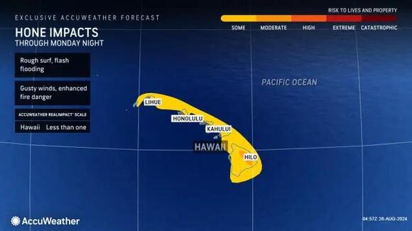
Tropical Storm Hone passing just south of Hawaii
Hone was named last Thursday as a swirling batch of showers and thunderstorms became better organized. Gusty winds, flooding rain and rough seas are expected to continue across portions of the Hawaiian Islands into Monday as Hone moves to the south.
As of late Sunday night, local time, a peak wind gust of 72 mph (at Kohala Ranch) and rainfall amount of 27.5 inches (Hakalau) was observed so far on Hawaii's Big Island. Over 17,000 customers were without power, as well, according to Poweroutage.us.
Hone became better organized this past weekend and gained wind intensity reaching hurricane strength at 5 a.m. Eastern time on Sunday morning. By Monday morning, Hone lost wind intensity and was a 70-mph tropical storm.
As Hone continues its westward track, wind gusts of 40-60 mph are expected to continue mainly across the western portions of the islands. Winds of this magnitude can bring down trees and cause power outages.
Winds can also increase the fire threat across the islands, especially on the western and southern rain-sheltered slopes of mountains and hillsides. A similar setup occurred last August as Hurricane Dora passed to the south. Gusty winds, drought and dry air triggered a deadly and destructive wildfire that became Hawaii's worst natural disaster.
Heavy rain will continue to occur across portions of the Hawaiian Islands through Monday.
As Hone continues to pull away from Hawaii on Monday, a general 1-2 inches of additional rain can fall, particularly on the windward side of the islands.
This magnitude of rain can lead to flash flooding and mudslides, especially but not limited to the windward—generally the northern and eastern—sides of the hills and mountains as the storm approaches.
Have the app? Unlock AccuWeather Alerts™ with Premium+
As the storm continues to move southwest of the individual islands, shifting winds will bring locally heavy rain to more of the south-facing slopes on Monday.
The RealImpact™ Scale factors in more than the Saffir-Simpson Wind Scale for Hurricanes. The Saffir-Simpson scale only measures the wind intensity of the center of the storm and does not account for the size, speed and other impacts even a near-miss from a storm might bring.
Hurricane Gilma to approach Hawaii later in the week
Wind, seas and rain may increase only a few days after Hone, depending on how much cool water in front of Gilma causes the hurricane to weaken. Gilma first ramped up to a major Category 3 hurricane during the middle of last week and restrengthened to a major Category 4 hurricane early Sunday morning, before again losing some wind intensity later in the day. As of early Monday morning, Gilma was a Category 2, 100-mph hurricane.
While Gilma will continue to move in a generally westerly direction and inch closer to Hawaii, the hurricane's track has been shifting and may continue to do so through the week.
The core of Gilma is forecast to pass just to the north and east of the islands with impacts ranging from showers, thunderstorms and gusty winds to ramping up on the Big Island, likely to begin late Tuesday night or Wednesday.
Gilma is expected to weaken considerably before reaching Hawaii, and it is possible that it will be reduced to a tropical depression or wind and rainstorm by the second half of the week.
The combination of both tropical cyclones will likely bring an extended period of rough seas and surf to the islands, which will pose dangers to boarders, swimmers and small craft.
And then there's Hector
East of Gilma is another tropical cyclone that became Tropical Storm Hector over the weekend.
There is a chance this system may track near Hawaii a few days after Gilma swings by. The latest information takes Hector to the north of the islands while losing some wind intensity.
Back-to-back tropical cyclone impacts are extremely rare
August tends to be the busiest month in terms of tropical threats to Hawaii, with 30 tropical cyclones affecting the islands since official record-keeping began in 1949. The month represents more than 40% of the approximately 70 impacts by tropical cyclones on the islands throughout the year.
Iniki was the most potent hurricane to directly strike the state. Iniki hit as a Category 4 hurricane on the Saffir-Simpson Scale in 1992. The only other hurricane to directly hit the islands was Dot in 1959 as a Category 1.
Two named storms have not passed within 300 miles of the main islands of Hawaii within a week since 1992. In an extremely rare occurrence in September 1992, Iniki was followed three days later by a direct strike by Orlene as a tropical depression. Two systems passed to the south of the islands in eight days in 1994.
Tropical storms and hurricanes do not have to directly strike Hawaii to cause significant danger and damage, which was demonstrated by Dora last August and Hurricane Lane in 2018.
Want next-level safety, ad-free? Unlock advanced, hyperlocal severe weather alerts when yousubscribe to Premium+on theAccuWeather app.AccuWeather Alerts™are prompted by our expert meteorologists who monitor and analyze dangerous weather risks 24/7 to keep you and your family safer.
Get updates delivered to you daily. Free and customizable.
It’s essential to note our commitment to transparency:
Our Terms of Use acknowledge that our services may not always be error-free, and our Community Standards emphasize our discretion in enforcing policies. As a platform hosting over 100,000 pieces of content published daily, we cannot pre-vet content, but we strive to foster a dynamic environment for free expression and robust discourse through safety guardrails of human and AI moderation.


 Most Popular
Comments / 0