Gilma, with much-reduced winds from its peak as a major hurricane, but still packing rain, will travel near Hawaii during the Labor Day. weekend.
Just days after Hurricane Hone passed to the south of Hawaii bringing gusty winds and locally flooding rain, Gilma is eyeing the islands with impacts just in time for the extended holiday weekend, AccuWeather meteorologists advise.
The second of a trio of tropical cyclones will make a run at Hawaii within the next week, a feat that is extremely rare.
Gilma is next on the list for this weekend
Gilma peaked as a Category 3 hurricane over the weekend, but winds were slowly on the decline early this week. Tuesday night local time, the tropical cyclone slipped to tropical storm status with 50-mph maximum sustained winds. On Thursday morning, Gilma was downgraded by the National Hurricane Center to a tropical depression with maximum sustained winds of about 35 mph. On Thursday afternoon, Hawaii time, Gilma became a tropical rainstorm.
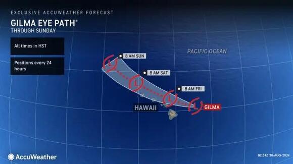
As Gilma tracks over cool water to the east of Hawaii, it will continue to lose wind intensity with some minor fluctuations and become less organized through the weekend.
The system will effectively become a squally rain and gale center as it tracks westward in the general direction of Hawaii, near or just to the north of the islands. However, even if the center of circulation holds together, it may not be as critical for impacts, as there will not be a strong eyewall to contend with.
Instead, its gusty showers and drenching thunderstorms will be more spread out and could bring more impacts than a small, compact hurricane.
"One key point to consider even with a poorly organized tropical feature, such as a tropical rainstorm that passes just to the north of the islands, is that some of the south-facing slopes of the islands may get more rain than if a hurricane, such as Hone, was passing by to the south," AccuWeather Lead Long-Range Meteorologist Paul Pastelok said.
While there can be localized flash flooding and mudslides, much-needed rain might occur in hard-to-reach drought areas. Typically, rainfall is plentiful on the north- and east-facing slopes of the islands due to the northeast trade winds. The northeast trades create a rain shadow effect on the south- and west-facing slopes, which leads to dry brush that is susceptible to catching fire.
Have the app? Unlock AccuWeather Alerts™ with Premium+
A storm passing by to the north tends to help pull some rain into these arid locations while a storm passing by to the south just amplifies the effect of the trade winds.
The leading showers and thunderstorms with locally gusty winds will begin on the Big Island late Thursday night or Friday and spread westward over the islands during the Labor Day weekend. Rough seas and surf will precede the rainfall by a day or so as swells from Gilma spread out.
Should Gilma's thunderstorms pulse while the storm tracks near Hawaii, excessive rain could fall and damaging winds could result in some areas.
Hector to dissipate
AccuWeather meteorologists are also monitoring Hector, located several hundred miles east-southeast of Gilma.
Hector has ingested a significant amount of dry air and was barely producing much in the way of showers and thunderstorms on Thursday. For this reason, AccuWeather meteorologists believe Hector will no longer bring significant impacts to Hawaii as it drifts well south of the islands into early next week.
At the very least, the close proximity of Gilma following Hone will keep surf and seas stirred up around the islands through the Labor Day weekend. The waves may interest surfers, but the different propagation of the waves from wintertime storms and the prevailing Northeast Trades can create dangerous conditions.
Want next-level safety, ad-free? Unlock advanced, hyperlocal severe weather alerts when yousubscribe to Premium+on theAccuWeather app.AccuWeather Alerts™are prompted by our expert meteorologists who monitor and analyze dangerous weather risks 24/7 to keep you and your family safer.
Get updates delivered to you daily. Free and customizable.
It’s essential to note our commitment to transparency:
Our Terms of Use acknowledge that our services may not always be error-free, and our Community Standards emphasize our discretion in enforcing policies. As a platform hosting over 100,000 pieces of content published daily, we cannot pre-vet content, but we strive to foster a dynamic environment for free expression and robust discourse through safety guardrails of human and AI moderation.


 Local News
Comments / 0