Get updates delivered to you daily. Free and customizable.
Alameda Post
Let’s Go Back in Time
By Dennis Evanosky,
2 days ago
User-posted content
We thought it would be fun to do a Way Back Machine walk this time. We set the Time Machine to November 1887, when Alameda Semi-Weekly Argus editor Truman Daniells published a map for all to enjoy. This artist-rendered map, which created a birds-eye view of Alameda, could have been yours for 25 cents—or five for just $1—back then. Daniells described how it was done.
Map originally published in the Alameda Semi-Weekly Argus. Annotations prepared by Dennis Evanosky for the Alameda Post . Click to enlarge.
“The town was laid out in blocks on heavy paper with every attention paid (to) distance, perspective, etc.,” he explained. “This the artists bent around a cardboard cylinder 8 to 10 inches in diameter. With this novel easel they traveled around every block in the city filling in from actual observation on the map.”
Some of the wealthier property owners commissioned individual views of their businesses or homes. They paid $20 for a 3-by-3-inch drawing. These included architect A. W. Pattiani. Daniels was pleased.
“We think the result is remarkably true to nature,” the Argus editor proclaimed. We’re featuring a close-up of this map that zooms in on our walk. We’ll bring a full-sized colorized version of the map for you to enjoy during the walk.
Join Dennis Evanosky and the Alameda Post for our latest walking tour on the West End. We’ll start on the old shoreline near the site of Alameda founders William Worthington Chipman and Gideon Aughinbaugh’s very expensive and unsuccessful “Peralta Wharf.” South Pacific Coast Railroad’s trains rolled by this spot from 1878 to 1906. The Southern Pacific Railroad’s Big Reds stepped in and carried their passengers by here from 1911 to 1938. Our walk will take us north on Third Street to Pacific Avenue. Had we walked down Third before 1877, we would have been on Kellogg Street instead. A. A. Cohen created the Town of Woodstock in 1864, he named this street for his wealthy benefactor, John Grover Kellogg, who made his fortune striking gold coins. We’ll meet at 10 a.m. at the intersection of Central Avenue and Third Street on Saturday, August 17 or Sunday August 25 . Tickets are $20 apiece.
We’re going to start at Third Street (A) and Taylor Avenue (B). Notice on the map that this intersection did not exist in 1887. In fact, we will be trespassing on Governor Henry Haight’s property (1). The Haight family had moved on by the time this map was made, however. The governor passed away in 1878, and his family had moved to Oakland. Anne, the matriarch of the family, was living on Alice Street. Her oldest son and his father’s namesake, Henry, was living just a block away on Harrison Street.
Gov. Henry H. Haight and his wife Anne lived in this home on West End Avenue (today’s Fourth Street). Haight was serving as governor when the University of California came into existence in 1868. When he died in 1878, Anne moved to Oakland. The governor’s business partner Henry Bacon was living in the home when the 1887 map was made. Photo Alameda Museum.
The governor’s former business partner, Henry Bacon, was living in the mansion. He had purchased the home from Anne after the governor died. Anne passed away in 1898. Not long after, Henry Bacon put the estate up for sale.
It will make things less confusing if you know that some of the streets on our tour changed their names in 1877. Kellogg Street is now Third Street. Kellogg was an 1865 street that had disappeared by the time Daniells made his map. West End Avenue on the map became our Fourth Street, and Second Avenue on the map is today’s Fifth Street.
One other fun fact: In 1955, Diversified Property Investments purchased the railroad right-of-way between Lincoln and Pacific avenues (D) and named the newly created street “Marshall Way.”
This area also had a “ditch” (2) that Charles Bowman created in 1852. This conduit, aptly named “Bowman’s Ditch,” ran from the marshland on the north, crossed what became Pacific Avenue and Marshall Way, and paralleled West End Avenue all the way into San Francisco Bay. Bowman dug the ditch as a water source.
He paid the owners of the Alameda peninsula, Gideon Aughinbaugh and William Worthington Chipman, for 144 acres adjoining his creation. He also told them of San Francisco Bay’s deeper water just off his waterway. They built “Peralta Wharf” at considerable expense. Chipman mentioned in his diary that the wharf needed 10,000 redwood logs but never made it clear whether they actually used that much timber. In the end, they were unable to convince ship owners to use this wharf instead of the ones nestled in Oakland Harbor.
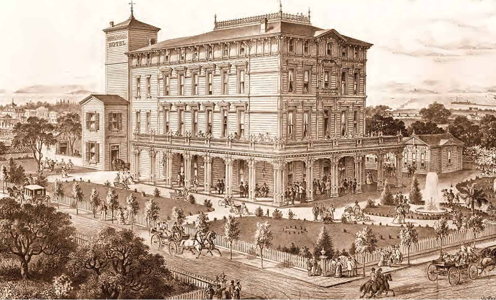
John and Herman Kohlmoos did a brisk hotel business in this four-story Italianate-style building from 1879 to 1886. The impressive structure stood at the site of today’s Longfellow Park until 1934 . Photo Alameda Museum.
As we near the intersection of West End Avenue (Fourth Street) we’ll happen upon a beautiful Gothic Revival home (3). Abram Rich built this trim, white home with its picture-perfect setting in 1865, less than a year after the San Francisco and Alameda Railroad started rolling through Alameda.
When we reach Marshall Way, we’ll be standing on that railroad’s right-of-way and one of the Bureau of Electracy’s massive light towers (4). The Bureau built 13 of these throughout town to brighten Alameda at night. A. A. Cohen had tracks laid across Alameda on today’s Lincoln Avenue in 1864. Lincoln was called Railroad Avenue until 1909, when it was renamed to honor Abraham Lincoln’s 100th birthday.
Cohen’s railroad station and wharf stood at the foot of Pacific Avenue, however. He built his tracks onto today’s Marshall Way (D), so they could reach Pacific Avenue and the railyards.
At this point, the Academy of Alameda stands just across Pacific Avenue , on the site where Nehemiah Clark built his terra cotta factory (5). Before Clark arrived, this piece of land belonged to Thomas Davenport.
The 1880 census lists Thomas living here with his wife, Caroline, his brother Matthew and his cousin James. Historian Woody Minor writes that Davenport made his living as a fur trader in Missouri and a wholesaler in Mexico. He arrived in California during the Gold Rush. Davenport owned 150 acres here and “built his house on the west half of his property, leasing out the remaining land for cultivation,” Minor writes.
Civil War veteran John London, left, married Flora Wellman, right, in 1876. The couple farmed land on Thomas Davenport’s property in Alameda for almost three years. John raised Flora’s son as his own. The young man—Jack London—attended West End School and grew up to be one of America’s greatest authors. Photos Sonoma State University.
Farmer John London, his wife Flora, daughters Eliza and Ida, and 4-year-old son Jack appear as the very next household on the same page of the 1880 federal census that lists Thomas Davenport. According to Russ Kingman in A Pictorial Life of Jack London , Jack London was born on January 12, 1876, to Flora Wellman at 615 Third Street in San Francisco. Jack’s father, astrologist William Chaney, denied paternity and left town. About nine months later on September 7, Flora married partially disabled Civil War veteran John London. The following year, John removed Eliza and Ida—daughters from a previous marriage—from the Protestant Orphan Asylum on Haight Street in San Francisco.
Then in 1880, when young John Jr. (“Johnny” to his family) was 4 years old, John Sr. and Flora moved to Alameda with the children. According to Kingman, London’s parents cultivated 20 acres of land near Thomas Davenport’s mansion. In 1882, 6-year-old Johnny started grade school at West End Primary School (6), on the site of today’s Longfellow Education Center. The family didn’t stay long. On January 7, 1883, John took up roots and moved his family to the Tobin Ranch in San Mateo County where they raised horses and grew potatoes.
Nehemiah Clark built his brick, pottery, and terra cotta manufacturing plant on Pacific Avenue at Fourth Street in March 1886. He used more than 600,000 of his fire-resistant bricks in the process. Southern Pacific Railroad extended a spur line to the plant to unload coal and clay and ship out finished products. Nehemiah’s sons, Albert and George, played important roles in the firm. Photo Alameda Museum. N. Clark and Son’s advertisement describes the company’s wide range of products. Photo Alameda Museum.
When Davenport died, his heirs sold a portion of his property to Clark. On his fascinating website about California brick-making , Dan Mosier tells us that Delaware native Nehemiah Clark arrived in California in 1850 and in 1864 established Pacific Pottery on the east side of Sacramento, where he made various clay products. These included vitrified sewer pipe, chimney pipe and his best-seller, the “Pacific” fire brick.
Mosier says that Nehemiah opened an office and depot on Market Street in San Francisco in 1880, where he sold fire brick and other clay products. In 1883, he moved his office to California Street. When he decided to move his pottery plant from Sacramento to be closer to the bustling San Francisco market, he selected a site in Alameda for his new works. He built his new plant—an enormous four-story building with more than 600,000 of his own bricks—at 401 Pacific Avenue (6). Historian Imelda Merlin tells us that the Clark factory contained four kilns and, at 28,500 square feet, was the largest building in Alameda. The building stood until 1963.
The map highlights other places of interest that we won’t get to on our walk, including the Borax Works (a); Pacific Coast Oil using A. A. Cohen’s old wharf (b); Alameda, Porter, Green Arbor, and Sunny Cove baths all together (c); Terrace Baths (d); Britt’s Hotel, which became Croll’s (e); and Civil War veteran O. W. Briggs’ home, demolished long ago and now home to Washington Park (f).
What a journey! The Way Back Machine’s batteries are running low, so we’ll have to sign off for now. Hope you enjoyed the ride.
Get updates delivered to you daily. Free and customizable.
It’s essential to note our commitment to transparency:
Our Terms of Use acknowledge that our services may not always be error-free, and our Community Standards emphasize our discretion in enforcing policies. As a platform hosting over 100,000 pieces of content published daily, we cannot pre-vet content, but we strive to foster a dynamic environment for free expression and robust discourse through safety guardrails of human and AI moderation.


 Most Popular
Comments / 0