Open in App
  • Local
  • U.S.
  • Election
  • Politics
  • Crime
  • Sports
  • Lifestyle
  • Education
  • Real Estate
  • Newsletter
  • Bring Me The News

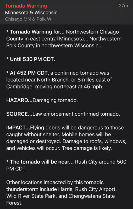
    Live updates: Severe storms moving across Minnesota

    By Joe Nelson,

    9 hours ago

    https://img.particlenews.com/image.php?url=1QfYia_0vEX8r2j00

    The National Weather Service has issued a severe thunderstorm watch ahead of a developing line of storms that have already produced multiple severe weather warnings in central and southwestern Minnesota.

    The storms are expected to increase in coverage and move east-northeast, running through the Twin Cities metro area and eastern areas of Minnesota between 4-7 p.m. We're tracking live updates as the storm situation evolves....

    5:24 p.m. — Gustnadoes on Mpls lake?

    Possible gustnadoes on Minneapolis lake? (0:26)

    5:02 p.m. — Confirmed tornado near North Branch

    https://img.particlenews.com/image.php?url=1gPDiB_0vEX8r2j00
    https://img.particlenews.com/image.php?url=296YIu_0vEX8r2j00

    4:16 p.m. — View from Shakopee

    4:12 p.m. — Wind, some rotation possible

    3:43 p.m. — Minneapolis in a warning

    A cell west of the metro is on approach and the NWS has put areas of the metro, including Minneapolis, in a severe thunderstorm warning for potential winds up to 60 mph.

    https://img.particlenews.com/image.php?url=0M5snL_0vEX8r2j00

    3:36 p.m. — Reports of wind damage

    Storm reports out of New Upm say multiple trees were down on power lines as the storm moved through. There was also a 59 mph wind gust in Paynesville and large branches down in Willmar.

    https://img.particlenews.com/image.php?url=1vmqQZ_0vEX8r2j00

    3:33 p.m — Latest radar as storms approach

    https://img.particlenews.com/image.php?url=2YjfPD_0vEX8r2j00

    2:36 p.m. — Severe thunderstorm watch issued

    https://img.particlenews.com/image.php?url=4SMEJn_0vEX8r2j00

    2:34 p.m. — 5 storms already have warnings

    Take a look at the radar as of 2:32 p.m. There are five cells within the clusters of storms that have severe thunderstorm warnings on them.

    https://img.particlenews.com/image.php?url=161LEB_0vEX8r2j00

    2:25 p.m. — Simulated future radar

    Storms will be capable of producing large hail and tornadoes, but the primary threat will be damaging winds up to 70 mph, according to the weather service.

    https://img.particlenews.com/image.php?url=2iXxB3_0vEX8r2j00
    The simulated future radar from the HRRR for 3 p.m. to midnight.

    WeatherBell

    2:15 p.m. — Twin Cities in middle of severe zone

    The Twin Cities are in the center of a level three of five enhanced risk. It's the area where the weather service has the most confidence in severe wind gusts, along with tornadoes spinning up within the line of storms.

    https://img.particlenews.com/image.php?url=0yiInD_0vEX8r2j00
    Expand All
    Comments / 0
    Add a Comment
    YOU MAY ALSO LIKE
    Most Popular newsMost Popular

    Comments / 0