Get updates delivered to you daily. Free and customizable.
Channel3000com News 3 Now
Tropical Storm Francine’s track shifts east with a bout of strengthening ahead
By By Elizabeth Wolfe, Mary Gilbert, Robert Shackelford and Eric Zerkel, CNN,
15 hours ago
(CNN) — Tropical Storm Francine is expected to strengthen into a hurricane Tuesday as it charges toward Louisiana where some communities were evacuating and slamming closed their floodgates in anticipation of the storm’s likely landfall there on Wednesday.
Francine was about 420 miles from Morgan City, Louisiana, Tuesday morning and packing maximum sustained winds of 65 mph – just 9 mph short of being a hurricane, according to the National Hurricane Center.
The strong tropical storm was dousing parts of far South Texas with a few inches of flooding rain and gusty winds Tuesday morning, but started to pull away Tuesday and track northeast through the Gulf of Mexico where it will start to intensify once again after battling hostile conditions overnight.
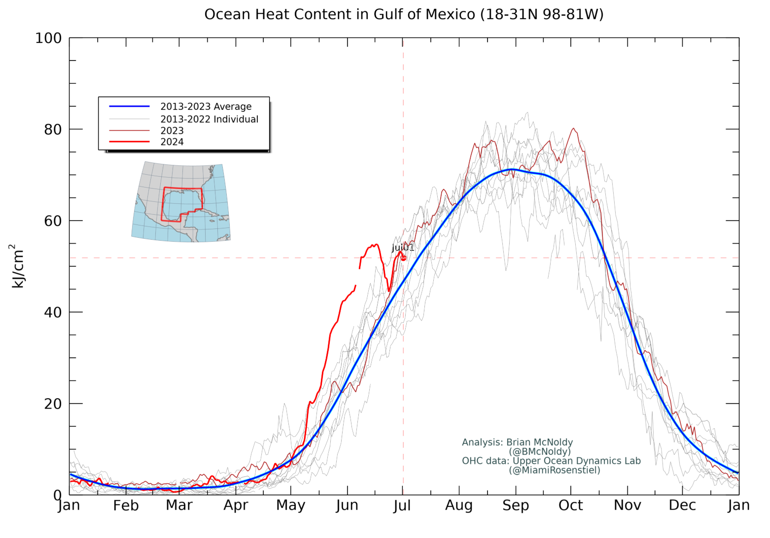
Forecasters expect the storm to strengthen significantly in the record-warm Gulf of Mexico and become a hurricane as early as Tuesday evening and keep strengthening through Wednesday morning.
The storm’s projected path has also been nudging to the east, which could aid intensification by giving it more time over the water and also implicate more of the New Orleans area. Because of the eastward shift, coastal Mississippi and Alabama are were placed under tropical storm and storm surge watches and warnings.
The storm could encounter more hostile conditions that could limit its strength before landfall, but it will not change the overall impact: Flooding rainfall, powerful winds and potentially life-threatening storm surge threaten to flood roads and cause extensive damage to homes and widespread power outages.
The most severe impacts are likely to be felt in southern Louisiana around the time of landfall, but the storm will be felt long before that over a wider area of the Gulf Coast.
Rain and scattered thunderstorms will continue along parts of the upper Texas and Louisiana coasts until Francine’s rain bands arrive overnight into Wednesday morning. Tropical storm-force winds could arrive as early as Wednesday morning.
Francine’s most significant threats
A storm’s winds may determine its official strength, but its the water that is most likely to kill. Francine is no different.
Francine will push several feet of the Gulf of Mexico onto normally dry areas across the western Gulf Coast in what’s called storm surge . Storm surge watches and warnings stretch along the coast from far northeastern Texas to the Mississippi-Alabama line. The storm surge threat here is the reason behind several evacuation orders across the Louisiana and Gulf coasts.
Water levels will begin to rise most severely as Francine nears a potential landfall along the central Louisiana coast, where surge levels could reach 10 feet above normal.
Heavy rain-caused flooding also presents a significant threat. Flood watches have been hoisted for parts of the Gulf Coast – some areas that are expected to get doused by Francine were soaked by a non-tropical system last week, so it will take less rain to cause flash flooding.
The outer rain bands of the storm could begin to impact the Gulf Coast Tuesday night, though the most torrential conditions will hold off until Wednesday morning.
The storm is expected to bring rainfall totals of 4 to 8 inches from the coastline of northeast Mexico to southern Mississippi, and some places in southeast Louisiana could see as much as 12 inches.
The storm should weaken quickly as it moves onshore Wednesday, but rainfall is expected to drench parts of the lower and middle Mississippi River Valley through the rest of the week.
Evacuations ordered along the Gulf Coast
Louisiana’s governor to issue a statewide emergency declaration ahead of Francine’s arrival. Gov. Jeff Landry said Monday he has already asked the Federal Emergency Management Agency to prepare to assist.
Evacuation orders expanded along the state’s coast Tuesday.
Mandatory and voluntary evacuations were set to go into effect in parts of Lafourche Parish on Tuesday afternoon, according the parish government. Mandatory evacuations were also in place for Zone 1 in Terrebonne Parish, the parish government said.
Mandatory evacuations orders were issued Monday and expanded Tuesday to the entirety of Louisiana’s Cameron Parish, according to an official’s social media . Both mandatory and voluntary evacuations were ordered farther east in Jefferson Parish’s town of Grand Isle , which was decimated by the Category 4 storm Ida in 2021.
Some parishes, including St. Mary and Terrebonne, started to close off floodgates and distribute sand bags Monday. Terrebonne Parish also declared a state of emergency , according to a news release.
Schools are closed across several Louisiana parishes on Wednesday and Thursday, including Jefferson , Terrebonne and Orleans , which encompasses New Orleans.
In Mississippi, people in the city of Pass Christian have begun to voluntarily evacuate.
Get updates delivered to you daily. Free and customizable.
It’s essential to note our commitment to transparency:
Our Terms of Use acknowledge that our services may not always be error-free, and our Community Standards emphasize our discretion in enforcing policies. As a platform hosting over 100,000 pieces of content published daily, we cannot pre-vet content, but we strive to foster a dynamic environment for free expression and robust discourse through safety guardrails of human and AI moderation.

 Local News
Comments / 0