‘We’re making progress’: Pine Fire that exploded across 7,000 acres SE of Pine Mountain now 25% contained
By Barney Lerten,
21 hours ago
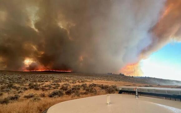
C.O. Fire Management Service Smoke pours skyward from fast-growing Pine Fire SE of Pine Mountain Monday evening Deschutes County Sheriff's Office Pine Fire on southeast side of Pine Mountain sent up large smoke plume Monday evening AlertWest Thick smoke billowed from the Pine Fire on the SE side of Pine Mountain. Dustin Hull Smoke billows from the Pine Fire on SE side of Pine Mountain, as seen Monday evening, as seen from Highway 20 and George Millican Road
(Update: New acreage, containment estimate; Isabella Warren is visiting fire area for report at Five)
Several smaller fires also stopped in C.O.; causes range from homeless camp smoker to burn barrel
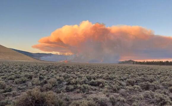
BEND, Ore. (KTVZ) – In only half a day, the Pine Fire that broke out southeast of Pine Mountain raced across about 7,000 acres, but officials reported 25% containment by Tuesday and said “we’re making progress” on stopping its rapid spread.
"It's a full suppression fire," officials said in a brief update at midday Tuesday, "with multiple agencies responding," federal, state and local.
Overnight, crews built bulldozer lines around part of the fire, officials said. Firefighters on Tuesday were continuing to construct dozer line and working to secure the perimeter, to keep the fire in its current footprint.
Isabella Warren is visiting the fire area to learn the latest and will have a report on NewsChannel 21 at Five.
The new fire quickly raced across at least 2,000 acres by nightfall, prompting expanded Level 3 and 2 evacuation alerts for the area, and put up a bright glow visible for many miles through the night.
Meanwhile, warm, windy weather kicked up several existing blazes around the region on Monday, spreading more smoke across the High Desert.
Also on Monday, several fires of various causes were stopped at small sizes Monday by firefighters around the Bend-Redmond area.
Incident 1002, soon named the Pine Fire, was reported around 4 p.m. on Prineville District BLM land about 22 miles southeast of Bend, in the Kotzman Basin, and quickly put up major smoke visible across a wide area and in dramatic fashion from the AlertWest Pine Mountain camera.
Resources from the Central Oregon Fire Management Service, Oregon Department of Forestry, Brothers-Hampton Rangeland Fire Protection Association and Alfalfa Fire District responded to the fire with several engines, a 10-person hand crew, two bulldozers and overhead resources. Firefighters on the ground were supported by aerial resources including an air attack, air tankers to drop retardant and a Type 1 helicopter to put water on the flames.
Around 8 p.m., officials confirmed in an update that the fire burning south of US Highway 20 was estimated at about 2,000 acres “and remains active on all sides. Additional resources are on order,” and crews will be working through the night, as the fire's nighttime glow can be seen for many miles, including in Prineville to the north.
The cause of the fire is under investigation, officials said.
Visit the official source for wildfire information in Central Oregon at centraloregonfire.org for wildfire updates or follow fire information on X/Twitter @CentralORfire . Call 9-1-1 to report a wildfire.
Pine Mountain might be best known for the University of Oregon-operated observatory at its summit. The facility is closed for the season, but its live camera had another view of the smoke coming from the nearby blaze.
Deschutes County Sheriff's Office evacuation announcement:
Update: October 7, 2024 | 8:30 PM
Due to continued growth of the Pine Fire, additional evacuation areas have been identified:
Level 3: Go Now! - west of Moffitt Rd. south of Hwy. 20 to Fox Butte Rd.
Level 2: Be Set - south of Hwy 20, west of Fox Butte Rd. north of the National Forest, east of Pine Mountain Rd.
Additionally, Level 2: Be Set - South of Hwy 20, west of Frederick Butte Rd. east of Moffitt Rd.
Level 2: Means “BE SET” to evacuate. You must prepare to leave at a moment’s notice. This level indicates there is significant danger to your area, and residents should either voluntary relocate to a shelter or with family and friends outside of the affected area, or if choosing to remain, to be ready to evacuate at a moment’s notice. Residents MAY have time to gather necessary items, but doing so is at their own risk. This may be the only notice you receive. Emergency services cannot guarantee that they will be able to notify you if conditions rapidly deteriorate. Area media services will be asked to broadcast periodic updates.
Level 3: Means “GO” evacuate now. Leave immediately! Danger to your area is current or imminent, and you should evacuate immediately. If you choose to ignore this advisement, you must understand that emergency services may not be available to assist you further. DO NOT delay leaving to gather any belongings or make efforts to protect your home. This will be the last notice you receive.
Meanwhile, crews were pulled off the northern flank of the Little Lava Fire 15 miles southwest of Bend Sunday afternoon due to increased fire activity. Warm, dry conditions and gusty winds led to several spot fires on the east side of the Edison No. 3 Trail. Crews returned Sunday evening and worked to find and douse spot fires.
Smoke from the Little Lava Fire was very visible Monday from the Sunriver and La Pine areas as the fire kept growing to the region. As of Monday morning, the Bachelor Complex had burned nearly 13,000 acres and was 63% contained.
To the south, near Crescent Lake, stronger than expected winds on Sunday kicked up fire activity on the over 2,800-acre Red Fire, putting up more smoke, along with the neighboring 208 Fire. It’s 15% contained
To the east, the Rail Ridge Fire near Dayville also was actively burning on the northwest flank on Monday, though officials said it remained with containment lines. Plans to use tactical firing operations to finish burning five miles of prepared containment line were delayed due to the stepped-up fire activity and conditions.,
The largest new Bend-area blaze on Monday afternoon around 1:20 p.m. burned about two acres near the Murphy Road and Country Club Drive roundabout, Bend Fire Deputy Fire Marshal Cindy Kettering said. It was traced to smoking materials at a homeless camp in the area.
In Tumalo, a small fire off Tweed Road that burned a 10-by-30 foot ara around 2:30 p.m. was traced to an electric gate controller, Kettering said.
She also advised that the fall burn season won’t open until there’s “meaningful rainfall,” as in several days’ worth.
In Redmond, a fire around noon off SE Evergreen Avenue was sparked from one power line touching another, sending sparks to the dry grass below. A fire off Crooked River Drive in the Terrebonne area was traced to an escaped burn barrel, Redmond Fire & Rescue Fire Marshal Tom Mooney said.
Get updates delivered to you daily. Free and customizable.
It’s essential to note our commitment to transparency:
Our Terms of Use acknowledge that our services may not always be error-free, and our Community Standards emphasize our discretion in enforcing policies. As a platform hosting over 100,000 pieces of content published daily, we cannot pre-vet content, but we strive to foster a dynamic environment for free expression and robust discourse through safety guardrails of human and AI moderation.


 Local News
Comments / 0