Get updates delivered to you daily. Free and customizable.
The Orange Leader
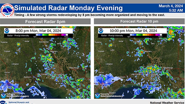
Main threats of large hail and damaging winds detailed today and Tuesday
By Staff Reports,
2024-03-04
Expand All
Read in NewsBreak
Comments / 0
Add a Comment
YOU MAY ALSO LIKE
 Most Popular
New York City, NY9 days ago
Total Apex Sports & Entertainment3 days ago
Lancaster County, PA7 days ago
Chicago, IL8 days ago
Tupelo, MS22 days ago
Massachusetts State12 days ago
WyoFile6 hours ago
Carol Perez23 days ago
Massachusetts State28 days ago
Town Talks5 days ago
Morristown Minute6 days ago
Savannah, GA7 days ago
Shenandoah, PA14 days ago
Get updates delivered to you daily. Free and customizable.
Welcome to NewsBreak, an open platform where diverse perspectives converge. Most of our content comes from established publications and journalists, as well as from our extensive network of tens of thousands of creators who contribute to our platform. We empower individuals to share insightful viewpoints through short posts and comments. It’s essential to note our commitment to transparency: our Terms of Use acknowledge that our services may not always be error-free, and our Community Standards emphasize our discretion in enforcing policies. We strive to foster a dynamic environment for free expression and robust discourse through safety guardrails of human and AI moderation. Join us in shaping the news narrative together.
Comments / 0