(STATE COLLEGE, PENN.) Storm-chasing for science can be exciting and stressful – we know , because we do it . It has also been essential for developing today’s understanding of how tornadoes form and how they behave.
In 1996 the movie “Twister ” brought storm-chasing into the public imagination as scientists played by Helen Hunt and Bill Paxton raced ahead of tornadoes to deploy their sensors and occasionally got too close . That movie inspired a generation of atmospheric scientists.
With the new movie “Twisters ” coming out on July 19, 2024, we’ve been getting questions about storm-chasing – or storm intercepts, as we call them.
Here are some answers about what scientists who do this kind of fieldwork are up to when they race off after storms.
What does a day of storm-chasing really look like?
The morning of a chase day starts with a good breakfast, because there might not be any chance to eat a good meal later in the day.
Our goal is to figure out where tornadoes are most likely to occur that day. Temperature, moisture and winds, and how these change with height above the ground, all provide clues.
There is a “hurry up and wait” cadence to a storm chase day. We want to get into position quickly, but then we’re often waiting for storms to develop.
A ‘hook echo’ on radar, typically a curl at the back of a storm cell, is one sign that a tornado could form. The hook reflects precipitation wrapping around the back side of the updraft. National Severe Storms Lab
Storms often take time to develop before they’re capable of producing tornadoes . So we watch the storm carefully on radar and with our eyes, if possible, staying well ahead of it until it matures. Often, we’ll watch multiple storms and look for signs that one might be more likely to generate tornadoes.
Once the mission scientist declares a deployment, everyone scrambles to get into position.
We use a lot of different instruments to track and measure tornadoes, and there is an art to determining when to deploy them. Too early, and the tornado might not form where the instruments are. Too late, and we’ve missed it. Each instrument needs to be in a specific location relative to the tornado. Some need to be deployed well ahead of the storm and then stay stationary. Others are car-mounted and are driven back and forth within the storm.
Vehicle-mounted equipment can act as mobile weather stations known as mesonets. These were used in the VORTEX2 research project. Dozens of scientists, including the authors, succeeded in recording the entire life cycle of a supercell tornado during VORTEX2 in 2009. Yvette Richardson
A whole network of observing stations will have been set up across the storm, with radars collecting data from multiple angles, photographers capturing the storm from multiple angles, and instrumented vehicles transecting key areas of the storm.
Not all of our work is focused on the tornado itself. We often target areas around the tornado or within other parts of the storm to understand how the rotation forms . Theories suggest that this rotation can be generated by temperature variations within the storm’s precipitation region, potentially many miles from where the tornado forms.
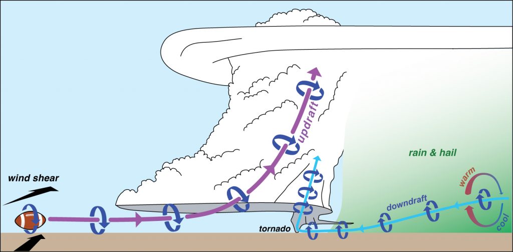
Formation of a tornado: Changes in wind speed and direction with altitude, known as wind shear, are associated with horizontal spin, similar to that of a football. As this spinning air is drawn into the storm’s updraft, the updraft rotates. A separate air stream descends through a precipitation-driven downdraft and acquires horizontal spin because of temperature differences along the air stream. This spinning air can be tilted into the vertical and sucked upward by the supercell’s updraft, contracting the spin near the ground into a tornado. Paul Markowski/Penn State
Through all of this, the teams stay in contact using text messages and software that allows us to see everyone’s position relative to the latest radar images. We’re also watching the forecast for the next day so we can plan where to go next and find hotel rooms and, hopefully, a late dinner.
What do all those instruments tell you about the storm?
One of the most important tools of storm-chasing is weather radar. It captures what’s happening with precipitation and winds above the ground.
We use several types of radars , typically attached to trucks so we can move fast. Some transmit with a longer wavelength that helps us see farther into a storm, but at the cost of a broader width to their beam, resulting in a fuzzier picture. They are good for collecting data across the entire storm.
Smaller-wavelength radars cannot penetrate as far into the precipitation, but they do offer the high-resolution view necessary to capture small-scale phenomena like tornadoes. We put these radars closer to the developing tornado.
An inside look at some of the mobile systems and tools scientists use in storm-chasing, including how team members monitor storms in real time.
We also monitor wind, air pressure, temperature and humidity along the ground using various instruments attached to moving vehicles, or by temporarily deploying stationary arrays of these instruments ahead of the approaching storm. Some of these are meant to be hit by the tornado.
Weather balloons provide crucial data, too. Some are designed to ascend through the atmosphere and capture the conditions outside the storm. Others travel through the storm itself, measuring the important temperature variations in the rain-cooled air beneath the storm. Scientists are now using drones in the same way in parts of the storm.
Symbols show the paths of over 70 balloon-borne probes that the authors’ team launched into a supercell thunderstorm. The probes, carried by the wind, mapped the temperature in the storm’s downdraft region, which can be a critical source of rotation for tornadoes. Luke LeBel/Penn State
All of this gives scientists insight into the processes happening throughout the storm before and during tornado development and throughout the tornado’s lifetime.
How do you stay safe while chasing tornadoes?
Storms can be very dangerous and unpredictable, so it’s important to always stay on top of the radar and watch the storm.
A storm can cycle, developing a new tornado downstream of the previous one. Tornadoes can change direction, particularly as they are dying or when they have a complex structure with multiple funnels. Storm chasers know to look at the entire storm, not just the tornado, and to be on alert for other storms that might sneak up. An escape plan based on the storm’s expected motion and the road network is essential.
In 1947, the Thunderstorm Project was the first large-scale U.S. scientific study of thunderstorms and the first to use radar and airplanes. Other iconic projects followed, including ones that deployed a Totable Tornado Observatory, or Toto, which inspired the ‘Dorothy’ instrument in the movie ‘Twister.’
Scientists take calculated risks when they’re storm chasing – enough to collect crucial data, but never putting their teams in too much danger.
It turns out that driving is actually the most dangerous part of storm-chasing, particularly when roads are wet and visibility is poor – as is often the case at the end of the day. During the chase, the driving danger can be compounded by erratic driving of other storm chasers and traffic jams around storms.
What happens to all the data you collect while storm-chasing?
It would be nice to have immediate eureka moments, but the results take time.
After we collect the data, we spend years analyzing it. Combining data from all the instruments to get a complete picture of the storm and how it evolved takes time and patience. But having data on the wind, temperature, relative humidity and pressure from many different angles and instruments allows us to test theories about how tornadoes develop.
Although the analysis process is slow, the discoveries are often as exciting as the tornado itself.
Yvette Richardson receives funding from the National Science Foundation and previously received funding from the National Oceanic and Atmospheric Administration. She is a member of the American Meteorological Society, the National Weather Association, and the American Geophysical Union, and serves on the Board of Trustees for the University Corporation for Atmospheric Research.
Paul Markowski receives funding from the National Science Foundation and previously received funding from the National Oceanic and Atmospheric Administration. He is a member of the American Meteorological Society, National Weather Association, and is affiliated with the University Corporation for Atmospheric Research.
Get updates delivered to you daily. Free and customizable.
Welcome to NewsBreak, an open platform where diverse perspectives converge. Most of our content comes from established publications and journalists, as well as from our extensive network of tens of thousands of creators who contribute to our platform. We empower individuals to share insightful viewpoints through short posts and comments. It’s essential to note our commitment to transparency: our Terms of Use acknowledge that our services may not always be error-free, and our Community Standards emphasize our discretion in enforcing policies. We strive to foster a dynamic environment for free expression and robust discourse through safety guardrails of human and AI moderation. Join us in shaping the news narrative together.


 Most Popular
Comments / 0