Get updates delivered to you daily. Free and customizable.
Alameda Post
Slow Streets, Public Transit, and Major Tube Closures
By Ken Der,
3 days ago
As part of a packed agenda on Wednesday, August 28 , the Transportation Commission heard informational project updates on the Link21 Program, Neighborhood Greenways Implementation and Slow Streets Program, State Route 61 Preventative Maintenance Project, and the Oakland Alameda Access Project.
A Slow Streets barricade on Santa Clara Avenue at Fifth Street. Photo Ken Der.
As part of an update to the Commission, Camille Tsao, Link21 Program Lead for CCJPA, announced the completion of the first project phase, which included the development of initial alignment concepts, service planning, and public outreach. The project team is now poised to identify whether the crossing will be built with broad-gauge (BART) or standard-gauge (similar to Capitol Corridor or Caltrain) railroad tracks.
Tsao touted the benefits of each technology, noting that a broad-gauge concept could improve service on existing BART lines and build redundancy into the system, while a standard-gauge concept could improve travel times, particularly for long-distance trips across the megaregion. Both concepts would promote equity and livability by improving station access as well as access to jobs and opportunities for priority populations.
Left: Potential Link21 service corridors for a BART expansion. Right: Potential Link21 service corridors for a regional rail expansion. Maps Link 21.
Geographically, Alameda is situated such that proposed tunnel alignments “serving Alameda are more promising” than concepts that skip over Downtown Oakland and Alameda, according to Tsao. A new station, perhaps in Alameda Point , could support land use development in the area and introduce new connections to the Inner East Bay, San Francisco, and the Peninsula.
Following the identification of crossing technology, Link21 will further define the project and develop a funding strategy.
Neighborhood Greenways and Slow Streets
Discussion over the next steps for Slow Streets and their eventual transition into “Neighborhood Greenways” occupied the majority of the meeting.
The Slow Streets Program began in 2020 and implemented “soft” closures to through traffic, using traffic barricades, on select Alameda streets. A primary purpose was to provide ample space for physical distancing during the COVID-19 pandemic, but Slow Streets also created new corridors for residents to travel more safely and sustainably around town.
Existing Slow Streets in Alameda. Map City of Alameda.
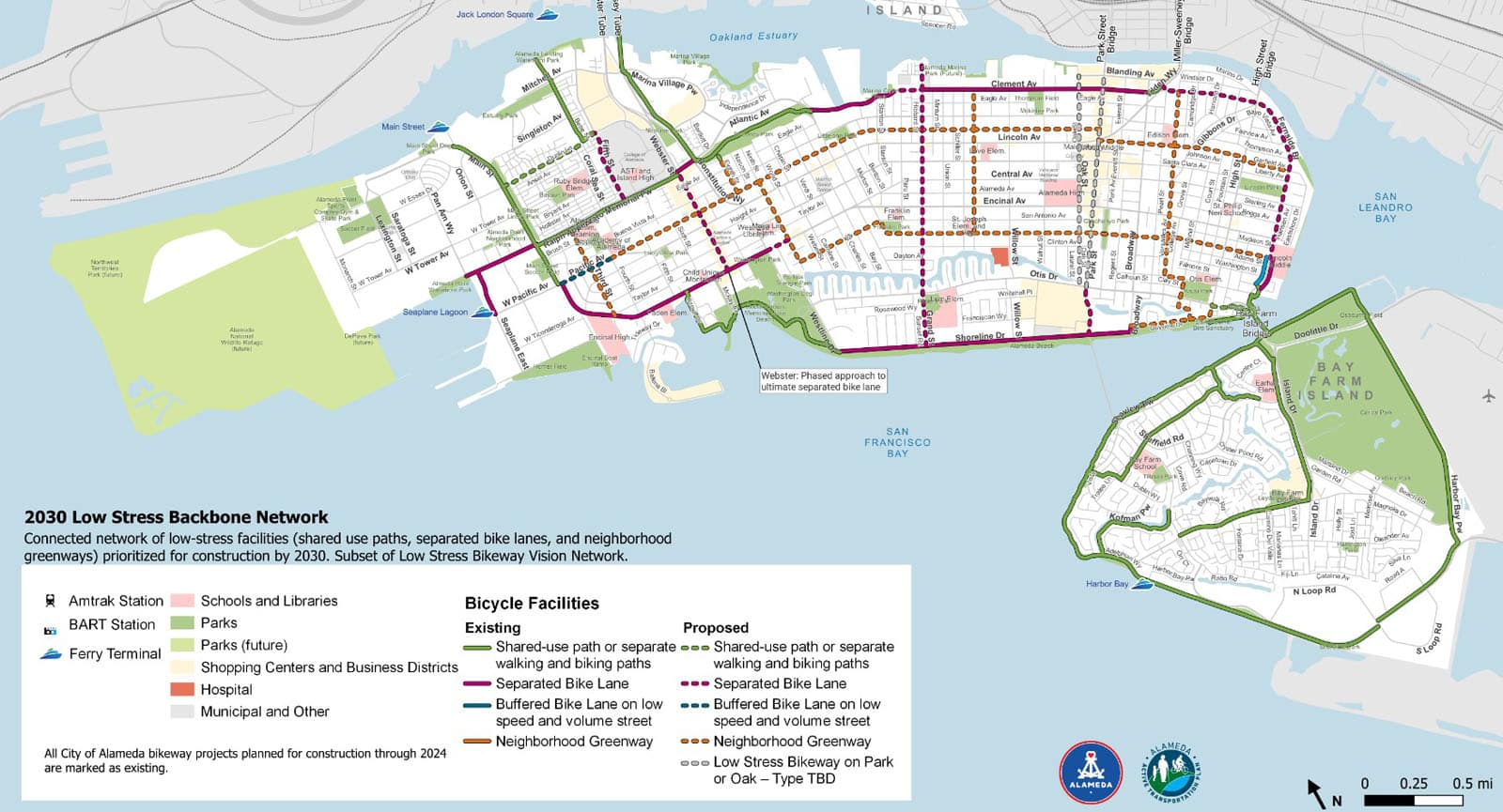
The existing Slow Streets along Pacific Avenue, San Jose Avenue, and Versailles Avenue will become “Neighborhood Greenways” between late 2024 and 2025. Finalized in late 2022, Alameda’s Active Transportation Plan (ATP) calls for the transformation of 10 miles of streets into Neighborhood Greenways , which are intended to be bicycle-and pedestrian-priority streets designed to maintain low vehicle volumes and speeds.
As part of the “2030 Low-Stress Backbone Network,” additional roadways across Alameda will be converted into Greenways in a phased approach between 2026 and 2030. Materials and methods could range from quick-build materials like paint and plastic posts to reduce crossing distances at intersections, to more permanent concrete installations of diverters or intersection traffic circles to enhance safety.
The 2030 Low-Stress Backbone Network as envisioned by the ATP. Map City of Alameda.
In response to ongoing maintenance costs and complaints from community members, City Council will decide at its September 17 meeting on one of the following options:
Option 1: Keep barricades in place , per existing Council direction (until the Slow Streets are converted to Neighborhood Greenways, or in the case of the Santa Clara Avenue Slow Street, until the Central Avenue Safety Project is complete).
Option 2: Remove all barricades (approximately 60) immediately.
Option 3: Hybrid —remove select barricades immediately and replace remaining ones with new, temporary flexible plastic posts.
A community survey that asked residents for feedback on those options resulted in mixed responses, but keeping the barricades garnered the most support for each Slow Street. Public commenters during the Transportation Commission meeting expressed similar sentiments.
“I’m not happy with the Slow Streets we have here. I never saw the purpose, except for…the beginning of COVID,” said Anne W. “I’m older, I do not feel safe walking down San Jose with more traffic there, which gives me a greater sense of safety.”
But several of her neighbors disagreed. Gabriela D. said, “I hope the barricades stay in place. I bring my grandkids down, we bike up and down the street and I’d like to see more traffic control. But I’m definitely in favor of keeping the Slow Streets and keeping them connected so we can make our way around Alameda.”
As a frequent pedestrian, Christy C. said the issue requires more public engagement and clearer messaging around the purpose of Slow Streets. “[Drivers] really don’t have a clue!” she said. “If they think anything about why [the barricades] are there, it’s COVID. And they don’t understand why the barricades aren’t down…and don’t see why they should be slowed down on their drive across Alameda.”
Commissioner Drew Dara-Abrams offered a clear—and admittedly specific—attempt at defining the purpose of Neighborhood Greenways.
“It’s the way that a majority of middle schoolers will get to school without their parents driving them,” Dara-Abrams proposed. “That’s not the stated goal of this program, but it’s those auto trips of less than four miles that the CARP (Climate Action and Resiliency Plan) identifies as the primary source of greenhouse gases [in Alameda]. That’s what’s under our control here.”
Commissioners generally favored keeping barricades in place on Slow Streets until Neighborhood Greenways are constructed.
Otis Drive
Caltrans Regional Project Manager Ron Kiiana provided the Commission with a status update on the Capital Preventative Maintenance project on State Route 61, which will introduce roadway pavement, drainage, and sidewalk accessibility improvements to portions of Broadway, Otis Drive, and Doolittle Drive in Alameda.
Project limits. Map Caltrans.
Kiiana discussed the scope of the project, highlighting several safety enhancements slated for Otis Drive. Those include the installation of rectangular rapid-flashing beacons (RRFBs) and sidewalk “bulb-outs” into the roadway to enhance pedestrian visibility and reduce crossing distance at the Mound Street intersection. New RRFBs will also be installed at the Versailles Avenue intersection. Both intersections are heavily used by students and families walking to nearby Otis Elementary School.
RRFB. Photo Federal Highway Administration.
The roadway will also feature high-visibility striping, although the roadway configuration will stay the same. A Caltrans traffic operations study, performed at the request of the City of Alameda , considered a “road diet” to change Otis Drive from two lanes in each direction to one lane in each direction with bike lanes and a median turn lane, and found that high traffic volumes “would create substantial congestion and delays” and that “traffic would divert to other local streets.”
Alan, a public commenter, spoke about crossing Otis Drive with his son, who attends Otis School.
“Several times, despite the RRFBs, cars did not stop. It is not a sufficient deterrent to slow cars or stop cars,” he said. “I would love to see something to slow the traffic approaching the intersections where people are crossing, because at the current rates cars are driving, it is not safe, especially for kids who are riding their bikes, scooters, or walking.”
The commissioners were equally skeptical, questioning whether the traffic speed and geometric characteristics of keeping a four-lane configuration along Otis Drive would continue to pose safety hazards to residents that travel along and across the High-Injury Corridor .
Dara-Abrams presented several slides of his own that included resident concerns and anecdotes about crashes and near misses with pedestrians.
“These are the types of crashes that can happen on a four-lane roadway configuration,” he said.” The critical component is building in design features…that lead to smoother auto travel, and reduce these types of conflicts. To be honest, it sounds like that got lost along the way.”
Chair Scott Weitze went further.
“It should fundamentally be: You enter Alameda, we are going to do the things we need to do to slow you down and get rid of two lanes in each direction—which, we have anecdotally and otherwise learned, makes people go faster—in a pretty residential neighborhood. And the failure to acknowledge that, it just seems like the fundamental goal is still not met.”
The project’s final design concludes at the end of September and construction is expected to begin in September 2025.
Oakland Alameda Access Project
The final item of the evening included an update on the Oakland Alameda Access Project . Led by the Alameda County Transportation Commission (Alameda CTC) , the $152 million project will realign freeway access for travelers leaving Alameda. The cornerstone of the project is a new on-ramp that will allow vehicles to veer right immediately after exiting the Posey Tube and curve in a horseshoe configuration near Jackson Street to directly access northbound Interstate 880, bypassing the existing route along Seventh Street through Chinatown. The project will also include pedestrian and bicycle improvements on Oakland city streets and through the Posey and Webster tubes.
Major components of OAAP. Graphic Alameda CTC.
While the City of Alameda generally supports the project, City staff have raised concerns that recent project plans propose the extended 24/7 closure of one lane in both the Posey and Webster Tubes in order to complete construction. The magnitude of the closures, which could last up to two years for the Posey Tube and eight months for the Webster Tube, exceed the previous expectation of intermittent, off-peak closures.
Acting Transportation Planning Manager Lisa Foster noted that significant travel delays could affect drivers, AC Transit bus operations, and business patronage in Alameda at all times of day.
“We have raised substantial concerns…about the delays that this continuous single-lane closure could cause for everybody in the Alameda community,” said Foster.
The City has contracted with HNTB, an engineering consulting firm, to provide an analysis of the construction plans to determine whether temporary and off-peak closures would be sufficient to complete the project.
Construction of the project is scheduled to begin in spring 2025 and be completed by summer 2028.
A new “horseshoe ramp” would take travelers directly onto I-880 upon exiting the Posey Tube. Still image from Alameda CTC video .
Get updates delivered to you daily. Free and customizable.
It’s essential to note our commitment to transparency:
Our Terms of Use acknowledge that our services may not always be error-free, and our Community Standards emphasize our discretion in enforcing policies. As a platform hosting over 100,000 pieces of content published daily, we cannot pre-vet content, but we strive to foster a dynamic environment for free expression and robust discourse through safety guardrails of human and AI moderation.


 Local News
Comments / 0