Get updates delivered to you daily. Free and customizable.
AccuWeather
Alberto makes landfall, pushes inland over Mexico; US impacts to ease
By Alyssa Glenny,
17 days ago
The first tropical storm of the Atlantic hurricane season will unleash torrential rain, flash flooding and mudslides over northeastern Mexico as flooding from heavy rain and storm surge eases in Texas into Friday.
Alberto, the first named system in the 2024 Atlantic hurricane season, made landfall around sunrise this morning near Tampico, Mexico, as a tropical storm with maximum sustained winds around 45 mph.
Alberto was named on Wednesday morning, June 19, as it tracked across the southwestern Gulf of Mexico. Around daybreak on Thursday, Tropical Storm Alberto moved ashore near Tampico, Mexico, and the storm will continue to advance inland and slowly unwind into Friday. Alberto was downgraded to a tropical depression at mid-morning, while moving to the west at 18 mph and packing sustained winds of 35 mph.
Despite being downgraded, Alberto will still pose a serious threat from excessive rainfall.
"Abnormally warm waters and a pocket of relatively low wind shear located in the Bay of Campeche allowed Alberto to gain enough organization on Wednesday to be upgraded to tropical storm status," explained AccuWeather Meteorologist and Lead Hurricane Forecaster Alex DaSilva.
On average, the first tropical storm forms in the Atlantic Ocean by June 20. With Alberto developing into a tropical storm on June 19, this season is progressing right on schedule. However, other systems being monitored in the short term could quickly escalate into named storms within days.
Heavy coastal rain and flooding are expected to ease in Texas but continue in Mexico through Thursday. Already, the heaviest rains have shifted well inland over Mexico while spotty thunderstorm activity lingered near the coast and in South Texas.
Rounds of intense downpours
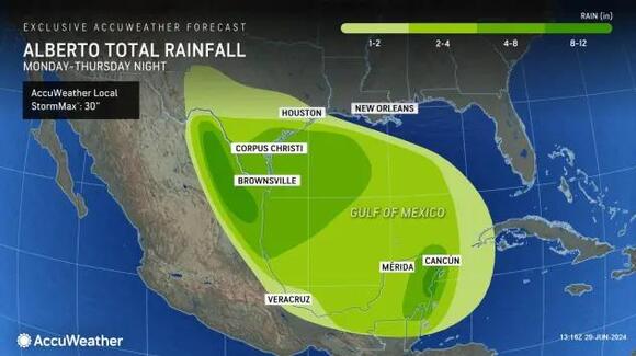
While the bulk of the rain has already fallen on much of southeastern Texas, rainfall totals as high as 8-12 inches can occur over the Big Bend area of Texas and especially in the higher elevations of northern Mexico, where the AccuWeather Local StormMax™ for rainfall is currently set at 30 inches.
Tropical wind gusts are forecast to reach speeds of 40-60 mph along the coastline in northeastern Mexico. The winds will create rough and dangerous surf along the coast, and mariners are cautioned to secure their vessels safely and steer clear of the hazardous conditions created by this feature as it tracks closer to land.
With Alberto moving well inland, the AccuWeather Local StormMax™ for wind gusts is 75 mph and is most likely to occur in strong thunderstorms in northeastern Mexico and southern Texas.
Have the app? Unlock AccuWeather Alerts™ with Premium+
In addition to the threat of strong winds and heavy rain across portions of Mexico and Texas, forecasters warn that mudslides can occur throughout the mountainous terrain of Mexico. Due to impacts across eastern Mexico, the AccuWeather RealImpact™ Scale is set at 1.
Storm surge along the coasts of northeastern Mexico, Texas and western Louisiana has already peaked and generally ranged between 1 and 3 feet. Locations around Houston and Galveston in Texas faced higher levels of storm surge, reaching up to 3-6 feet in some low-lying areas. Storm surge and above-normal tides will slowly ease into Friday with the center of Alberto inland and slowly unwinding.
Residents are urged to heed any warnings given by professionals and emergency management personnel. Storm surges can result in extensive damage and be one of the greatest threats to life as a storm impacts a region.
Due to the impacts of storm surge, rain and wind, the AccuWeather RealImpact™ Scale for the U.S. is 1.
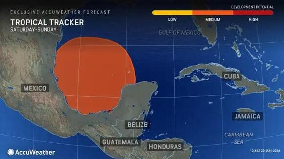
Watching for 2nd tropical system in southwest Gulf area
This weekend, another tropical system may ramp up across the Bay of Campeche and Gulf of Mexico. Forecasters say that a "rinse and repeat" of the early to midweek pattern can occur across the northeastern Mexico and South Texas coastlines.
"There is a moderate chance for development from June 21-23 across a similar area in the Gulf of Mexico. This feature will need to be watched for possible impacts on the Gulf coasts of the United States and Mexico this weekend into early next week," explained AccuWeather Meteorologist Andrew Kienzle.
Depending on the intensity and track of this new disturbance, rain, wind, coastal flooding and surf will likely build along much of the Texas and northeastern Mexico coasts again.
Want next-level safety, ad-free? Unlock advanced, hyperlocal severe weather alerts when yousubscribe to Premium+on theAccuWeather app.AccuWeather Alerts™are prompted by our expert meteorologists who monitor and analyze dangerous weather risks 24/7 to keep you and your family safer.
Get updates delivered to you daily. Free and customizable.
Welcome to NewsBreak, an open platform where diverse perspectives converge. Most of our content comes from established publications and journalists, as well as from our extensive network of tens of thousands of creators who contribute to our platform. We empower individuals to share insightful viewpoints through short posts and comments. It’s essential to note our commitment to transparency: our Terms of Use acknowledge that our services may not always be error-free, and our Community Standards emphasize our discretion in enforcing policies. We strive to foster a dynamic environment for free expression and robust discourse through safety guardrails of human and AI moderation. Join us in shaping the news narrative together.


 Most Popular
Comments / 0