Get updates delivered to you daily. Free and customizable.
The Conversation U.S.
What is an Atlantic Niña? How La Niña’s smaller cousin could affect hurricane season
By Annalisa Bracco, Georgia Institute of Technology and Zachary Handlos, Georgia Institute of Technology,
11 hours ago
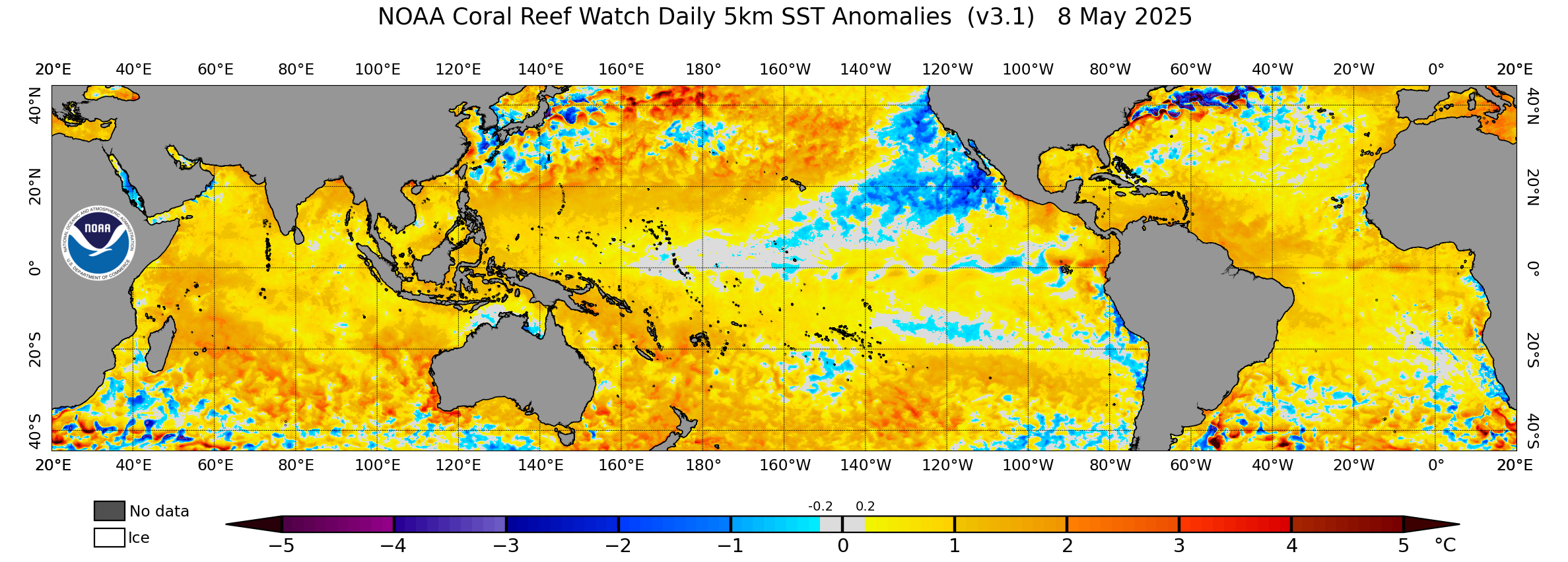
Cooling streaks indicate the potential for two Niña's at once – Pacific and Atlantic, a rare event. NOAA Coral Reef Watch
The North Atlantic has been running a fever for months, with ocean surface temperatures at or near record highs . But cooling along the equator in both the Atlantic and eastern Pacific may finally be starting to bring some relief , particularly for vulnerable coral reef ecosystems.
This cooling comes from two climate phenomena with similar names: La Niña, which forms in the tropical Pacific, and the less well-known Atlantic Niña.
La Niña is part of the El Niño–Southern Oscillation , a well-known climate phenomenon that has widespread effects on climate and weather around the world.
During La Niña, sea surface temperatures in the tropical Pacific dip below normal. Easterly trade winds then strengthen, allowing more cool water to well up along the equator off South America. This cooling affects weather around the world. During La Niña’s opposite, El Niño, water temperatures are warmer than normal.
La Niña and its opposite, El Niño, explained. NOAA.
A similar climate phenomenon, Atlantic Niña , occurs in the Atlantic Ocean but at a much smaller scale and amplitude. Its temperature swings are typically less than 1.8 degrees Fahrenheit (1 degree Celsius) cooler than average, while Pacific La Niñas often exceed 2.7 F (1.5 C) .
The Atlantic Niña typically peaks around July or August. It tends to have a shorter duration than its bigger Pacific cousin, and much more modest and local impacts. Atlantic Niñas generally have the opposite effect of Atlantic Niños, which tend to reduce rainfall over Africa’s Sahel region and increase rainfall in Brazil and the countries that surround the Gulf of Guinea, such as Ghana, Nigeria and Cameroon.
While much weaker than their Pacific counterpart, Atlantic Niñas can, however, partially counteract La Niñas by weakening summer winds that help drive the upwelling that cools the eastern Pacific.
Why are both happening now?
In July and August 2024, meteorologists noted cooling that appeared to be the development of an Atlantic Niña along the equator.
At the same time, waters along the equator in the eastern Pacific were also cooling, with La Niña conditions expected there by October or November.
A map of sea surface temperature anomalies shows cooling along the tropical Atlantic and eastern Pacific regions, but much warmer than average temperatures in the Caribbean. NOAA Coral Reef Watch
Getting a Pacific-Atlantic Niña combination is like finding two different pendulums that are weakly coupled to swing in opposite directions moving together in time – it’s rare but not impossible . The combinations of La Niña and Atlantic Niño, or El Niño and Atlantic Niña are more common.
In the tropical Atlantic, the winds at the ocean surface have been weak through most of the summer, and the sea surface temperatures there were quite warm until early June , so signs of an Atlantic Niña emerging were a surprise.
Good news or bad for hurricane season?
The Atlantic Niña may initially suggest good news for those living in hurricane-prone areas.
Cooler than average waters off the coast of Africa can suppress the formation of African easterly waves. These are clusters of thunderstorm activity that develop off Africa in the Northern Hemisphere tropical latitudes and travel westward.
These waves can form into tropical disturbances and eventually tropical storms or hurricanes. Tropical storms draw energy from the process of evaporating water associated with warm sea surface temperatures. So, cooling in the tropical Atlantic could weaken this process. That would leave less energy for the thunderstorms, which would reduce the probability of a tropical cyclone forming.
Two reasons are behind the busy forecast: The near record-breaking warm sea surface temperatures in much of the North Atlantic can strengthen hurricanes. And the expected development of a Pacific La Niña tends to weaken wind shear – the change in wind speed with height that can tear apart hurricanes. La Niña’s much stronger effects can override any impacts associated with the Atlantic Niña.
Exacerbating the problem: Global warming
The past two years have seen exceptionally high ocean temperatures in the Atlantic and around much of the world’s oceans. The two Niñas are likely to contribute some cooling relief for certain regions, but it may not last long.
In addition to these cycles, the global warming trend caused by rising greenhouse gas emissions is raising the baseline temperatures and can fuel major hurricanes .
Zachary Handlos receives funding from the National Science Foundation.
Annalisa Bracco does not work for, consult, own shares in or receive funding from any company or organization that would benefit from this article, and has disclosed no relevant affiliations beyond their academic appointment.
Get updates delivered to you daily. Free and customizable.
It’s essential to note our commitment to transparency:
Our Terms of Use acknowledge that our services may not always be error-free, and our Community Standards emphasize our discretion in enforcing policies. As a platform hosting over 100,000 pieces of content published daily, we cannot pre-vet content, but we strive to foster a dynamic environment for free expression and robust discourse through safety guardrails of human and AI moderation.


 Most Popular
Comments / 0