Get updates delivered to you daily. Free and customizable.
TheConversationAU
Get set for more extreme weather across Australia this spring and summer
By Andrew King, Senior Lecturer in Climate Science, The University of Melbourne,
23 hours ago
Australia is no stranger to extreme weather. From heatwaves and droughts to flooding rains, hailstorms or fire weather, our continent experiences it all.
To help Australians prepare for these hazards, the Bureau of Meteorology regularly briefs emergency services and governments, along with providing forecasts and advanced warnings for the public when severe weather approaches.
The latest spring and summer briefing shows the rest of this year is likely to be warmer than normal, with more extreme heat events possible.
We need to prepare for fire risks and severe storms. There’s also every chance the nation could experience multiple extreme events at any one time – concurrently or in rapid succession – in different parts of the country. Here’s what we expect to see.
Our most severe weather usually starts in October
Australia’s severe weather season is really from October to April.
With those unusually extreme events already happening across much of Australia, many people will be worried about the next few months.
The Bureau of Meteorology monitors current conditions and the drivers of Australian climate, then forecasts weather for the coming days and climate conditions for the coming months.
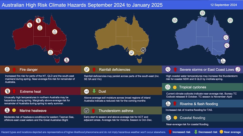
On Friday, the bureau’s general manager for environmental prediction, Matt Collopy, presented this outlook below at the National Situation Room in Canberra.
The Bureau of Meteorology’s spring and summer climate hazards outlook. 2024-25 Higher Risk Weather Season National Preparedness Briefing.
What will the rest of 2024 look like?
Australia’s climate and the likelihood of severe weather varies depending on the behaviour of climate drivers, such as the El Niño-Southern Oscillation and Indian Ocean Dipole . This is particularly true at this time of year, when the connections between these drivers and Australian weather and climate are strongest.
At the moment, we have neutral conditions in both the Pacific and Indian Oceans, but a higher-than-normal likelihood of a La Niña developing. Without strong climate drivers, the seasonal outlook for Australia is less certain than if we had established El Niño/La Niña or positive/negative Indian Ocean Dipole events in place.
Nevertheless, with a higher chance of La Niña, a slightly wetter-than-normal outlook, and above-average rates of runoff already flowing into some eastern Australian rivers, the chance of river flooding is higher than normal for the next few months, particularly in Tasmania. On the plus side, wetter than average soils across much of eastern Australia reduces the risk of dust storms in coming months.
Western and Central Victoria, on the other hand, have had a dry few months and river flows are below average. Drought is continuing and there’s not a strong signal for either wet or dry conditions in the seasonal outlook for this region.
The risks of a very warm spring
Having just experienced the warmest August on record , it is perhaps no surprise that Australia is likely to have another very warm spring. This is accompanied by a heightened chance of extreme heat events.
Continued high temperatures in the seas around Australia raise the chance of marine heatwaves, particularly in the Tasman Sea this spring.
With the warmer conditions and a lack of a strong rainfall signal in the forecast, there is a raised risk of bushfires this spring across much of northeastern Australia, as well as in the drought-affected areas of Victoria and southeastern South Australia. A summer bushfire outlook will come in November.
The bureau is also warning people in and around Canberra to beware of thunderstorm asthma , in which storms induce breathing difficulties. But these events are hard to forecast this far out from October-December, when such events are most frequent.
Similarly, while tropical cyclones are a major weather hazard across northern Australia, it is hard to make useful forecasts for the summer and early autumn season at this stage. The bureau will publish its tropical cyclone outlook next month.
Climate and water long-range forecast, issued 12 September 2024.
Preparing for more extremes
With so much potential for extreme weather and significant risks to lives and livelihoods, it’s useful to know what lies ahead.
The outlook helps Australians prepare for the severe weather on the horizon. As the climate varies from one year to the next, the likelihood of different types of severe weather changes. This is happening on top of background trends related to the warming of the planet.
In the future, with continued global warming, Australians will experience more extreme heat and there will more often be a heightened risk of bushfires.
In Australia’s southwest and southeast, we expect droughts to worsen too, while increases in short-duration extreme rainfall are on the cards for most of us.
Forecasting of extreme weather will continue to improve, helping us prepare for some hazards. But reducing greenhouse gas emissions will also help to limit rises in the frequency and intensity of these extreme weather events.
Andrew King receives funding from the ARC Centre of Excellence for 21st Century Weather and the National Environmental Science Program.
Get updates delivered to you daily. Free and customizable.
It’s essential to note our commitment to transparency:
Our Terms of Use acknowledge that our services may not always be error-free, and our Community Standards emphasize our discretion in enforcing policies. As a platform hosting over 100,000 pieces of content published daily, we cannot pre-vet content, but we strive to foster a dynamic environment for free expression and robust discourse through safety guardrails of human and AI moderation.
 Local News
Comments / 0