Deadly storm Beryl has intensified and regained hurricane status as it barrels towards southern Texas.
It's expected to unleash brutal winds and rain as the storm's outer bands are already battering the coast and locals brace for the powerful tempest that has already carved a deadly trail through parts of Mexico and the Caribbean.
The National Hurricane Center released an update at 1 am Central Standard Time, positioning the storm approximately 30 miles (48.2 kilometers) southeast of Matagorda, Texas, and about 95 miles (152.8 kilometers) northeast of Corpus Christi.
The hurricane is packing top sustained winds of 80 mph (128.7 kph) and is moving northwest at 10 mph (16 kph). A hurricane warning has been issued for the Texas coast from Mesquite Bay north to Port Bolivar, according to the center.
READ MORE: First pictures show Hurricane Beryl batter Texas with strong winds and heavy rain ahead of arrival
READ MORE: Map shows Hurricane Beryl's path as storm expected to make landfall in Texas as hurricane
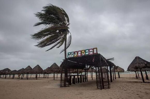
Residents along the Texas coast have boarded up windows and evacuated beach towns under evacuation orders. The storm is expected to make landfall early Monday in the middle of the Texas coast around Matagorda Bay, an area about 100 miles (161 kilometers) south of Houston.
However, officials warn that the path could still change. As the storm approaches the coast, Texas officials issued warnings on Sunday about potential power outages and flooding. They also expressed concern that not enough residents and beach vacationers in Beryl's path had heeded warnings to evacuate.
"One of the things that kind of trigger our concern a little bit, we've looked at all of the roads leaving the coast and the maps are still green," stated Texas Lt. Gov. Dan Patrick, who is currently acting governor while Gov. Greg Abbott is on international travel.

"So we don't see many people leaving." Tropical storm winds spanned 115 miles (185 kilometers) from the center, and the hurricane center highlighted residents should prepare for possible flash floods in parts of middle, upper and eastern Texas as well as Arkansas as the storm slowly shifts to the north and then moves northeast later Monday.
Along the Texas coast, many residents and entrepreneurs took typical storm precautions but relayed uncertainty regarding the storm's intensity.

In Port Lavaca, Jimmy May added plywood over the windows of his electric supply business and voiced he wasn't worried about potential storm surges. He recounted how his enterprise had evaded flooding during an earlier hurricane that resulted in a 20-foot (6-meter) storm surge.
"In town, you know, if you're in the low-lying areas, obviously, you need to get out of there," he conveyed. Nearby at the marina, Percy Roberts guided his neighbor Ken Waller on how to properly safeguard his boat as heavy winds rolled in from the bay Sunday evening.
"This is actually going to be the first hurricane I'm going to be experiencing," Waller said, feeling a mix of nerves and safety as he prepares to follow Roberts' guidance. "Pray for the best but expect the worst, I guess."

Beryl, the earliest storm to escalate into a Category 5 hurricane in the Atlantic, has left at least 11 people dead in its wake through the Caribbean en route to Texas. The ferocious storm tore apart homes and infrastructure with its violent winds and surges, powered by the unusually warm Atlantic waters.
The storm's rapid intensification, with Beryl gaining 35 mph (56 kph) in wind speed within 24 hours on three separate occasions, meets the official weather service criteria for rapid escalation.
Experts are pointing to Beryl's sudden and intense development as an early-season monster as a sign of what may come in the Atlantic hurricane belt, given the heated waters of the Atlantic and Caribbean.
Texans have been put on high alert as officials urge preparations along the coast for potential impacts from flooding to strong winds due to Hurricane Beryl. Warnings stretch from Baffin Bay to Sargent, encompassing a vast area including Corpus Christi and south of Houston.

Houston faces another serious rainfall threat from Beryl, after recent storms have already caused widespread power outages and flooding in America's fourth-largest city. Forecasters have issued a flash flood watch across a broad area of the Texas coast, anticipating up to 10 inches (25 centimeters) of rain in certain regions.
Forecasts predict potential storm surges between 4 and 7 feet (1.22 and 2.13 meters) above ground level around Matagorda. The warnings cover the same coastal areas where Hurricane Harvey made landfall in 2017 as a Category 4 hurricane, significantly more potent than Beryl's anticipated intensity upon reaching land.
As Beryl approached, those hoping to fly out of the area found their opportunities dwindling. By Sunday afternoon, hundreds of flights from Houston's two major commercial airports were delayed, with dozens cancelled, according to FlightAware data.
In Corpus Christi, officials urged visitors to end their trips early and return home if possible. Residents were advised to secure their homes by boarding up windows if necessary and using sandbags to protect against potential flooding.
The White House announced on Sunday that the Federal Emergency Management Agency had dispatched emergency responders, search-and-rescue teams, bottled water, and other resources along the coast.
Several coastal counties issued voluntary evacuation orders for flood-prone low-lying areas. Local officials also prohibited beach camping and encouraged tourists traveling over the Fourth of July holiday weekend to relocate recreational vehicles from coastal parks.
Last week, Beryl, then a Category 2 hurricane, wreaked havoc in Mexico, toppling trees but causing no injuries or deaths before weakening to a tropical storm as it traversed the Yucatan Peninsula. Before reaching Mexico, Beryl left a trail of devastation in Jamaica, Barbados, and St. Vincent and the Grenadines.
The storm claimed lives in several countries: three in Grenada, three in St. Vincent and the Grenadines, three in Venezuela, and two in Jamaica.
 Local Texas State
 Most Popular
Comments / 0