Get updates delivered to you daily. Free and customizable.
Talk Radio 1370
As Beryl's forecast track shifts east, rain chances dropping for Austin area, Hill Country
By Kasey Johns,
1 day ago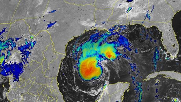
Expand All
Read in NewsBreak
Comments / 0
Add a Comment
YOU MAY ALSO LIKE
 Local Texas State
Corpus Christi, TX22 hours ago
 Most Popular
Texas State1 day ago
Florence, KY11 hours ago
Hawaii State2 days ago
Missouri State29 days ago
Conroe, TX2 days ago
Total Apex Sports & Entertainment25 days ago
Chicago, IL5 days ago
Georgia State2 days ago
Virginia State1 day ago
Bucks County Beacon5 days ago
Massachusetts State23 days ago
Carthage, MO4 days ago
Virginia State3 days ago
Webb City, MO6 days ago
Total Apex Sports & Entertainment7 days ago
Get updates delivered to you daily. Free and customizable.
Welcome to NewsBreak, an open platform where diverse perspectives converge. Most of our content comes from established publications and journalists, as well as from our extensive network of tens of thousands of creators who contribute to our platform. We empower individuals to share insightful viewpoints through short posts and comments. It’s essential to note our commitment to transparency: our Terms of Use acknowledge that our services may not always be error-free, and our Community Standards emphasize our discretion in enforcing policies. We strive to foster a dynamic environment for free expression and robust discourse through safety guardrails of human and AI moderation. Join us in shaping the news narrative together.
Comments / 0