Get updates delivered to you daily. Free and customizable.
New York Post
Hurricane Beryl makes landfall on Carriacou Island as life-threatening, dangerous conditions lash region
By FOX Weather,
7 hours ago
An extremely dangerous and life-threatening situation is unfolding across the southern Windward Islands in the Caribbean as strengthening Hurricane Beryl gets set to make landfall as a Category 4 hurricane in the next hour or so with potentially catastrophic wind damage and life-threatening storm surge.
“Take action now to protect your life!” the NHC said . “Residents in Grenada, the Grenadine Islands and Carriacou Island should not leave their shelter as winds will rapidly increase within the eyewall of Beryl.”
The NHC urged residents to remain inside throughout the passage of the life-threatening conditions and “do not venture out in the eye of the storm.”
St. Lucia implements nationwide shutdown ahead of Hurricane Beryl
For those who live in the region, the weekend was spent preparing for the storm’s onslaught by placing coverings on windows of homes, filling up gas tanks and picking up last-minute supplies after it became clear that Hurricane Beryl would continue to strengthen as it approached island nations like Barbados and St. Lucia, where Hurricane Warnings remain in place.
Hurricane Beryl is set to make landfall on Carriacou Island in the Caribbean Sea. AP Photo/Ricardo Mazalan A map of the Category 4 hurricane making its way through the southern Caribbean. NOAA / GOES East / USA TODAY NETWORK
The office of St. Lucia Prime Minister Philip J. Pierre said all residents should remain indoors until the all clear is given after a nationwide shutdown was implemented ahead of Hurricane Beryl.
Hospitals and wellness centers on the island activated emergency plans, shelters have been opened for residents, and police and fire departments are on high alert and stand ready to respond to emergencies should any arise during the hurricane.
The prime minister’s office also said utility crews would be out across the island in full force once Hurricane Beryl moves out of the region.
— OPMSaintLucia🇱🇨 (@opmsaintlucia) July 1, 2024 Barbados braces for Beryl by closing schools, airports
Residents of Barbados have been preparing for the impact of Hurricane Beryl since the end of last week.
Barbados Prime Minister Mia Amor Mottley took to social media on Friday and then again Sunday to urge her constituents to take the necessary actions to protect themselves from the storm.
While the worst of Hurricane Beryl is no longer expected to hit the island, it could still have a devastating impact.
“We still need to be extremely vigilant,” Mottley said Sunday night. “You can tell that there’s bad weather in the atmosphere.”
The Barbados Light and Power Company said it did not plan to shut down electricity ahead of the storm, but emergency procedures were in place.
“Our protection systems are designed to automatically trip any circuits impacted by the hurricane,” the company said . “Additionally, our teams will be in control centers throughout the night, monitoring systems.”
The island has also opened dozens of shelters for residents if needed, and Mottley asked residents to stock up on food and water.
Waves crashing down on a pier in Bridgetown, Barbados as Beryl passes through on July 1, 2024. AP Photo/Ricardo Mazalan A tree knocked down by Beryl in Bridgetown. Photo by CHANDAN KHANNA/AFP via Getty Images
“We expect that the system will affect us, but we give thanks that we do not believe that it will be the worst of the hurricane-force winds, but still tropical storm winds,” Mottley said Sunday night. “And we’ve seen what tropical storms have done to us in the past. Both in terms of loss of property, loss of roofs and loss of other infrastructure.”
While power wasn’t expected to be shut down ahead of Hurricane Beryl, the island shut down the water system in preparation for the storm.
The Barbados Water Authority said the shutdown of the water system was precautionary to protect the critical infrastructure.
A man boarding up the windows of his shop in Bridgetown on June 30, 2024. Photo by CHANDAN KHANNA/AFP via Getty Images
Schools have also been closed across Barbados, and Grantly Adams International Airport closed at 7 p.m. Sunday. The facility will remain closed until further notice.
Where is Hurricane Beryl?
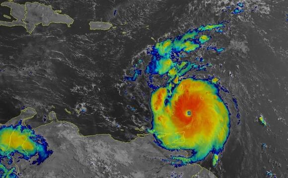
As of the latest advisory from the National Hurricane Center (NHC), Hurricane Beryl was about 35 miles northeast of Grenada and about 15 miles east-southeast of Carriacou Island.
Hurricane Beryl has intensified again with maximum sustained winds of 140 mph and a minimum central pressure of 956 millibars, making it a Category 4 on the Saffir-Simpson Hurricane Wind Scale.
Hurricane-force winds (74-plus mph) extend outward up to 40 miles from the center, and tropical-storm-force winds (39-plus mph) extend outward up to 125 miles.
The latest forecast cone for Beryl. Fox Weather
The NHC said that a weather station in Crown Point, Tobago, reported sustained winds of 46 mph and a gust to 54 mph.
There have also been multiple reports of downed trees, flooded streets, power outages and storm surge flooding in the Grenandines, Grenada, Barbados and Tobago.
On Beryl’s forecast trajectory, the storm’s center is expected to move across the Windward Islands over the next hour or so and then across the southeastern and central Caribbean later Monday through Wednesday.
Hurricane conditions are now occurring within the Hurricane Warning area. Potentially catastrophic wind damage is expected where the core of Beryl is moving through portions of the southern Windward Islands, including Carriacou Island, Grenada and the Grenadine Islands.
For top headlines, breaking news and more, visit nypost.com.
Get updates delivered to you daily. Free and customizable.
Welcome to NewsBreak, an open platform where diverse perspectives converge. Most of our content comes from established publications and journalists, as well as from our extensive network of tens of thousands of creators who contribute to our platform. We empower individuals to share insightful viewpoints through short posts and comments. It’s essential to note our commitment to transparency: our Terms of Use acknowledge that our services may not always be error-free, and our Community Standards emphasize our discretion in enforcing policies. We strive to foster a dynamic environment for free expression and robust discourse through safety guardrails of human and AI moderation. Join us in shaping the news narrative together.


 Most Popular
Comments / 0